Asia
| largest continent , covering almost third of the world’s land area highest place on the earth :Mount Everest (8848mtrs above sea level lowest place on the earth: Dead Sea shore (399mtrs below sea level) |
| physicaldivision | - Northern Lowlands :comprise the Serbian plain which extends between theUral mountains (W) and river Lena (E)
- Central mountains :comprising fold mountains and plateaus
- Southern plateaus :formed of very old rocks , the southern plateaus comprising the plateau of Arabia, the Deccan plateau and the plateau of Yunnan
- Great river valleys: some of these river systems – the Tigris-Euphrates, The Indus, The Ganga-Brahmaputra, the Ayeryarwaddy, the Mekong, the Sikiang, the Chang Jiang (Yangtze- kiang) and the Huang He – are very old.
- Island groups : Indonesia, the Philippines and Japan
|
| mountains | Asia has more mountain than any other continent. Himalaya, Karakoram, Altai, Elbruz, Zagros, Urals. Kunlun , Tein Shan Pamir Knot(Roof of the world):large group of rugged peaks and deep valleys(lies where Afghanistan, china , Pakistan and Central Asian Republics meet) Tarim Basin : Between the Kunlun and the Tein Shan |
| rivers | Euphrates, Tigris, Ganga, Hwang Ho, Amur, Sikiang, the Yangtze is Asia’s longest river. |
| deserts | Arabian Desert, Gobi Desert, Thar Desert |
| lakes | Baikal (Siberia ): deepest lake in world ; Caspian Sea, Aral Sea |
| straits | Strait of Malacca, Bering Strait |
| Coastline | 129077km |
|
|
|
|
|
|
|
|
|
|
| Africa | Second largest continent, one-fifth of the land area: separated from Europe by the Mediterranean Sea and from Asia by the Red Sea. In the north-west: Gibraltar, northeast: Suez Canal; strait of Bab-el Mandeb connect Africa to Eurasia: Africa has largest tropical area in the world. |
| physicaldivision | - Low Africa (consisting northern, western nd central )
- Costal Lowlands
- Northern highlands
- Saharan Plateau
- Western Plateau
- Nile Basin
- Congo Basin
| - High Africa (consisting eastern and southern Africa)
- Rift system: spl physical feature of Africa, consist of the Great Rift Valley (series of parallel cracks in the earth), extends from Ethiopia in the East to Mozambique in the southeast. Rich in volcanic soil
- Eastern highlands
- Southern Plateau
- Coastal Lowlands
- Madagascar
|
| mountains | Atlas( extending from Morocco to Tunisia ,non –volcanic), Drakensberg, Mt. Kilimanjaro(in Tanzania) and Mt. Kenye (in Kenya) are volcanic activity |
| rivers | Nile(longest river in the world, drains into the Mediterranean sea ) , Zaire(Congo: carries the greatest volume of water among all the rivers of Africa)), Niger(discharge into the Atlantic), Limpopo and Zambezi(drain into Indian ocean)
, Orange, ,Nyasa, Turkana |
| deserts | cover two-fifths of Africa Sahara(world’s largest desert; stretches across northern Africa from the Atlantic sea to the red sea), Kalahari, Namib |
| lakes | Victoria: largest lake in Africa and source of river Tanganyika, Rudolf, Albert ,Nyasa, Turkana |
| straits | strait of Babel-Mandeb, strait of Gibraltar |
| Coastline | ---- |
|
|
|
|
|
|
|
|
|
|
| north America | Third largest continent, extending from the Arctic Ocean in the north to south America in the south. |
| physical division | - Canadian Shield: huge area of ancient rocks covers most of Canada; reservoir of valuable mineral resources like gold, silver, nickel, iron, and copper, platinum; made up of swamps nd no. of lakes: Great Bear, Winnipeg and Great Lakes (Superior, Huron, Erie, Ontario, and Michigan). The famous Niagara Falls is located between Lake Erie and lake Ontario
- The Appalachian Mountains/Eastern Highlands
- The Central plains :cover flat river basin of the Missouri-Mississippi
- Western Cordilleras: intermontane Plateaus- the Great Basin (largest intermontane Plateau of continent) active volcano in Alaska and Mexico.
|
| mountains | Rockies(north America’s largest mountain range), Alaska(north America’s highest mountain range), Cascade, Sierra Madre Mt McKinley(6194m): north America’s highest mountain |
| rivers | Mississippi, Missouri, Rio Grande, Mackenzie. Columbia Mississippi- Missouri-Ohio: continent’s largest river system Grand Canyon of river Colorado- largest in world |
| deserts | Mojave, Sonoran |
| lakes | Superior(largest freshwater lake in world), Huron, Erie, Ontario, Great Bear , Great Slave ,Great Salt Lake in Utah ( saltier than sea) |
| straits | Bering strait |
| Coastline | About 300000km (longer than any other continent ) |
|
|
|
|
|
|
|
|
| South America | fourth largest continent , surrounded by water – the Caribbean Sea (north), the Atlantic Ocean (northeast and east) , the Pacific ocean (west) and the Dark Passage (south) the Isthmus of Panama : connected to central America by narrow strip of land |
| physical division | - Western coastal strip
- Western Mountains
- The central plains :covering about three-fifths of south Africa made up of LALMOS (rolling grasslands in Orinoco river basin of Colombia and Venezuela), THE SELVA:tropical rain forest of the Amazon river basin in Bolivia, Brazil and Peru) , THE GRAN CHACO(HARDWOOD SERIAL FOREST IN NORTHG-CENTRAL Argentina , western Paraguay and southern Bolivia ), THE PAMPAS(vast grasslands in Argentina)
- Eastern Highlands: consist of the Guyana Highlands and the Brazilian Highlands
|
| mountains | Andes : called western mountains, from Venezuela in the north to Tierra del Fuego in the south , young fold mountain second highest mountain system in the world ,next to Himalaya , world’s largest mountain ranges above sea level Mt Aconcagua(6959m)in Argentina : tallest mountain in western hemisphere Cotopaxi in Ecuador: highest active volcano in the world. |
| rivers | Amazon: world’s second longest river but has the largest drainage basin , Orinoco, Parana, Paraguay , The Rio de le Plata, the Magdalena-Cauca, the San Francisco the Angel Falls in southern-eastern Venezuela- highest water fall in the world |
| deserts | Atacama, Patagonia |
| lakes | lake Maracaibo, Lake Titicaca |
| straits | Strait of Magellan |
| coastline | 32000km , Tierra del Fuego( largest islands ), the Juan Fernandez the Falkland and the Galapagos |
| Europe | sixth in terms of area of continents ; extends from the arctic Ocean (North) to the Mediterranean Sea , the Black Sea and the Caucasus Mountains (south) and from the Atlantic Ocean (west) |
| physical division | - Northwest Mountains: include some of the oldest rock formations on earth
- North European Plains: extends from Urals in east to Atlantic coast in west.
- The Central Uplands: include the Meseta (Spain and Portugal)The Massif Central and Juna Mountains (France), the Black Forest (Germany)
- The Alpine System :stretching from the Atlantic Ocean in west to Caspian sea in East
|
| mountains | Alps(covering part of south –eastern France, north Italy, most of Switzerland ,parts of southern Germany, Austria and Northern Yugoslavia), the Apennines, the Alpines Pyrenees, Carpathians, Urals, Balkans The highest mountain peak of Europe is Mount Elbrus (5633m) in the Caucasus. |
| rivers | Volga: longest river of Europe (flowing thru Russia – Caspian Sea), Danube( 2nd longest river of Europe , drains into Black Sea) , Rhine(flows thru Alps –western Germany – Netherlands- North Sea) ,Po, Dnieper, Don, Vistula, Elbe, Oder |
| deserts | No desert |
| lakes | Lake Ladoga (Europe’s largest freshwater lake in Russia). The salt water Caspian sea: which lies partly in Europe and partly in Asia, is the world’s largest lake (Europe’s lowest point). Finland : country of 60000 lakes, known as ‘land of thousand lakes’ |
| straits | Strait of Gibraltar |
| coastline | 60957km |
|
|
|
|
|
|
|
|
| Australia | lies entirely in Southern Hemisphere |
| physical division | - Western Plateau : covers two-third of Australia ; The Nullarbor Plain : vast, dry ,treeless plateau
- Central Lowlands:
- Eastern Highlands
|
| mountains | Great Dividing Range , Mount Kosciusky(2228m)- highest peak in Australia |
| rivers | Murray: originating from the Snowy mountains in Alps , continents’ longest permanently flowing river, fed by Darling in dry season ;Darling |
| deserts | Gibson Desert, Great Sandy Desert, Great Victoria Desert, Simpson Desert ; cover third of Australia |
| lakes | Lake Eyre (lowest point in Australia) |
straits
Author----
| Bass Strait ; world largest coral reef: Barrier Reef
Nisha Dolas
|
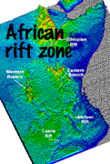 Africa's Great Rift Valley is a 6,000-mile crack (fissure) in the earth's crust, stretching from Lebanon to Mozambique. One of its most dramatic sections slices through East Africa, dividing Kenya into two segments. Geologists know that the Rift Valley was formed by violent subterranean forces that tore apart the earth's crust. These forces caused huge chunks of the crust to sink between parallel fault lines and force up molten rock in volcanic eruptions. Evidence that this process, called rifting, is still in progress comes from the many active and semi-active volcanoes, located along the Rift. Evidence of volcanic activity along the rift is provided by the presence of numerous boiling hot springs.

![Reblog this post [with Zemanta]](http://img.zemanta.com/reblog_e.png?x-id=5d45793d-8667-4ace-865d-6c54d16f7b28)
