Tuesday, August 17, 2010

Some Important Lines/International Borders


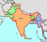
The Radcliffe Line became the border between India and Pakistan on 17 August 1947 after the Partition of India. The line was decided by the Border Commissions chaired by Sir Cyril Radcliffe, who was to divide equitably 175,000 square miles (450,000 km2) of territory with 88 million people.

The Durand Line refers to the border between Afghanistan and Pakistan, which is poorly marked and approximately 2,640 kilometers (1,610 miles) long. It was established after the 1893 Durand Line Agreement between the Government of colonial British India (Pakistan was part of the British Indian empire) and Afghan Amir Abdur Rahman Khan for fixing the limit of their respective spheres of influence. It is named afterHenry Mortimer Durand, the Foreign Secretary of British India at the time.

The McMahon Line is a line agreed to by Great Britain and Tibet as part of Simla Accord, a treaty signed in 1914. Although its legal status is disputed, it is the effective boundary between China and India.


The Curzon Line was a demarcation line between the Second Polish Republic and Bolshevik Russia, first proposed on December 8, 1919 at the Allied Supreme Council declaration.

The Oder-Neisse line  is the border between Germany and Poland which was drawn in the aftermath ofWorld War II. 

The Molotov Line was a system of fortifications built by the Soviet Union in the years 1940–1941, along its new western border after it annexed the Baltic States, Eastern Poland and Bessarabia. 

The Stalin Line was a line of fortifications along the western border of the Soviet Union. Work began on the system in the 1920s to protect the USSR against attacks from the West. The line was made up of concrete bunkers and gun emplacements, somewhat similar but less elaborate than the Maginot Line. It was not a continuous line of defenses along the entire border but rather a network of fortified regions, meant to channel the potential invaders along certain corridors. 


The Maginot Line , named after French Minister of Defense AndrĂ© Maginot, was a line of concrete fortifications, tank obstacles, artillery casemates, machine gun posts, and other defenses, which France constructed along its borders with Germany and Italy, in the light of experience from World War I, and in the run-up to World War II. Generally the term describes only the defenses facing Germany, while the term Alpine Line is used for the Franco-Italian defenses.

The Alpine Line or Little Maginot Line was the component of the Maginot Line that defended the southeastern portion of France


Radcliffe Line                       Durand Line                             McMahon Line 
 
 Source -- Wikipedia

Friday, August 6, 2010

Types of floods


Major Flood Prone Area across the World


1. Slow-Onset Floods

  • Slow-Onset Floods usually last for a relatively longer period, it may last for one or more weeks, or even months. As this kind of flood last for a long period, it can lead to lose of stock, damage to agricultural products, roads and rail links.

  • Slow onset floods like those that hit Bangladesh every year can also be lethal but tend to give people much more time to move to higher ground. When deaths occur, they are much more likely to be due to disease, malnutrition or snakebites. In 2007, floods in China displaced tens of thousands of snakes into neighboring areas, increasing the risk of attacks. Slower floods are also less likely to sweep away property, although it may still be damaged or destroyed. Areas are likely to remain under water for much longer. In India in 2007, some were unable to return to their homes for months.


2. Rapid-Onset Floods

  • Rapid-Onset Floods last for a relatively shorter period, they usually last for one or two days only. Although this kind of flood lasts for a shorter period, it can cause more damages and pose a greater risk to life and property as people usually have less time to take preventative action during rapid-onset floods.


3. Flash Floods

  • Flash Floods may occur within minutes or a few hours after heavy rainfall, tropical storm, failure of dams or levees or releases of ice jams. And it causes the greatest damages to society.


Flooding can also be divided into different categories according to their location:
1. Coastal Floods
  • Coastal Floods usually occur along coastal areas. When there are hurricanes and tropical storms which will produce heavy rains, or giant tidal waves created by volcanoes or earthquakes, ocean water may be driven onto the coastal areas and cause coastal floods.

2. Arroyos Floods
  • A arroyo is river which is normally dry. When there are storms approaching these areas, fast-moving river will normally form along the gully and cause damages.

3. River Floods
  • This is the most common type of flooding. When the actual amount of river flow is larger than the amount that the channel can hold, river will overflow its banks and flood the areas alongside the river. And this may cause by reasons like snow melt or heavy spring rain.

4. Urban Floods
  • In most of the urban area, roads are usually paved. With heavy rain, the large amount of rain water cannot be absorbed into the ground and leads to urban floods.


cloud-burst-ireland-jim-gola.jpg (472×700) What is a cloudburst?A cloudburst is sudden copious rainfall. It is a sudden aggressive rainstorm falling for a short period of time limited to a small geographical area.

Meteorologists say the rain from a cloudburst is usually of the shower type with a fall rate equal to or greater than 100 mm (4.94 inches) per hour.

Generally cloudbursts are associated with thunderstorms. The air currents rushing upwards in a rainstorm hold up a large amount of water.

If these currents suddenly cease, the entire amount of water descends on to a small area with catastrophic force all of a sudden and causes mass destruction. This is due to a rapid condensation of the clouds.

They occur most often in desert and mountainous regions, and in interior regions of continental landmasses.

During a cloudburst, more than 2 cm of rain may fall in a few minutes. They are called 'bursts' probably because it was believed earlier that clouds were solid masses full of water. So, these violent storms were attributed to their bursting.

Record Cloudbursts


Duration↓
Rainfall
Location
Date
1 minute
1.9 inches (48.26 mm)
Leh, Jammu & Kashmir, India
06 August, 2010
1 minute
1.5 inches (38.10 mm)
Barot, Himachal Pradesh, India
26 November, 1970
5 minutes
2.43 inches (61.72 mm)
Port Bells, Panama
29 November, 1911
15 minutes
7.8 inches (198.12 mm)
Plumb Point, Jamaica
12 May, 1916
20 minutes
8.1 inches (205.74 mm)
Curtea-de-Arges, Romania
7 July, 1947
40 minutes
9.25 inches (234.95 mm)
Guinea, Virginia, USA
24 August, 1906


Monday, August 2, 2010

Quiz (Focus--Soil in India)


Q 1:Which type of soil occupy the plains (from Punjab to Assam) and also occur in the valleys of Narmada and Tapti in M.P. & Gujarat, Mahanadi in the MP and Orissa, Godawari in A.R and Cauvery in T.N.
Black
Alluvial
Red


Q 2:..............soil is also called Regur and is ideal for cotton crop.

Red
Black
Alluvial


Q 3:........... soil are mainly formed due to the decomposition of ancient crystalline rocks like granites and gneisses and from rock types rich in minerals such as iron and magnesium.
Black
Red
Alluvial


Q 4:...............is best for tea, coffee, rubber, cinchona, coconut and suitable for rice and millet cultivation if manured and is found in parts of Western Ghats, Eastern Ghats, Rajmahal hills, Maharashtra, Karnataka, Kerala, Orissa, West Bengal, Assam, Tamil Nadu, etc.
Laterite
Red
Black


Q 5:The changes in the cropping pattern in the Indira Gandhi Canal Command Area are a living example of the utility of the .............. soils.
desert
alluvial
black


Q 6:....................Soil is known by different names: Reh, kallar, USAR, etc.
Black
Alluvial
Red


Q 7:For example, if one is travellers through the State of Tamil Nadu, one may observe that the ploughed fields in the districts of Salem and Periyar are ......... while those in Coimbatore and Ramanathapuram are ............
grey,brown
black,red
red,black


Q 8:.....................is a natural or artificial material containing silica in reactive form.
Fly Ash
Pig Iron
Pozzolana


Q 9:The co-ordinating unit of an All India Coordinated Research Project on “Management of Salt Affected Soils and Use of Saline Water in Agriculture” is also located at .............
Bharuch
Lucknow
Karnal


Q 10:Soil Conservation Society of India (SCSI) Regd. was established in year 1952 at ?
Hazaribagh
Karnal
Jamshedpur