North Africa consists of five countries that border the Mediterranean Sea—EGYPT, LIBYA, TUNISIA, ALGERIA, and MOROCCO.
 The SAHARA DESERT, the dominant feature of the North African landscape, sweeps across the southern part of the region.The Sahara serves as a geographical boundary between North Africa and sub-Saharan* Africa, except in Egypt. It also marks a transition zone from the largely Arab population of North Africa to black Africa of the south. The SAHARA DESERT, the dominant feature of the North African landscape, sweeps across the southern part of the region.The Sahara serves as a geographical boundary between North Africa and sub-Saharan* Africa, except in Egypt. It also marks a transition zone from the largely Arab population of North Africa to black Africa of the south.The Land. North Africa has three main geographic features: the Sahara, the ATLASOUNTAINS in the west, and the NILE RIVER ANd DELTA in the east. North Africa has three main geographic features: the Sahara, the ATLASOUNTAINS in the west, and the NILE RIVER ANd DELTA in the east.The Atlas Mountains—a complex cluster of ranges, ridges, plateaus, and basins—stretch for 1,200 miles along the North African coast from southwestern Morocco across Algeria to northeastern Tunisia. The tallest peaks are in the High Atlas range in south-central Morocco, which has many snowcapped peaks. South of the Atlas Mountains is the dry and largely barren expanse of the Sahara. In places the desert is cut by irregular watercourses called wadis—streams that flow only after rainfalls but are usually dry. The Sahara's major landforms include ergs, large seas of sand that sometimes form into huge dunes; the hammada, a level rocky plateau without soil or sand; and the reg, a level plain of gravel or small stones. The Sahara covers the southern part of Morocco, Algeria, and Tunisia, and most of Libya. Only two regions of Libya are outside the desert: Tripolitania in the northwest and Cyrenaica in the northeast. Most of Egypt is also desert, except for the Nile River and the irrigated land along its banks. The Nile Valley is a narrow green and fertile thread that runs the length of the country. The Egyptian desert also contains oases, fertile areas around natural water sources. Oases are scattered through other parts of the desert as well. Climate, Water, and Resources.Coastal North Africa has a Mediterranean climate, with hot summers and mild, damp winters. Along the Atlas chain, the mountains trap moisture-laden clouds blowing south from the Mediterranean Sea. The moisture falls as rain on the mountains' northern slopes. As a result, these slopes and the coastal area between them and the sea are well-watered and fertile, compared with the more arid conditions on the southern side of the mountains. Similar conditions exist in Libya, where cliffs and low mountains separate Tripolitania and Cyrenaica from the desert interior.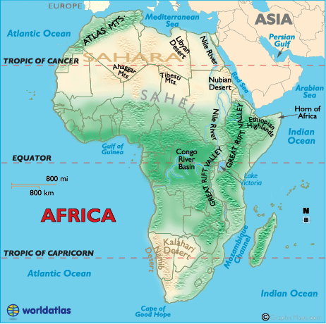 Throughout North Africa, the availability of water has always been the chief factor in determining where and how people live. In Egypt, 95 percent of the people live within a short distance of the Nile River or in the delta at its mouth on the Mediterranean Sea. Water from the river is used to irrigate fields of cereal grains, vegetables, cotton, and other crops. In the other North African countries, about 90 percent of the people live within 200 miles of the coast, generally in valleys that have streams and rivers. These areas are suitable for agriculture, especially with the aid of irrigation. Citrus fruits, olives, and grapes are major crops. Farther south, drier hills and grasslands bordering the desert have long been the home of pastoralists* who raise herds of sheep, goats, cattle, and camels. The only farming in the desert takes place in oases, where the main crops raised are date palms, fruit, and cereal grains. North Africa possesses valuable mineral resources. Libya and Algeria have extensive deposits of petroleum and natural gas. Industrial development of these resources has been underway since the 1950s, and fuel exports are a major source of revenue for these countries. Egypt and Tunisia have oil industries as well, though on a smaller scale. The region also contains small quantities of other minerals, such as copper, zinc, and manganese. Morocco and Tunisia have fairly significant deposits of phosphates, while iron ore is found in Algeria, Libya, and Tunisia. The People. North Africa's geographical setting has determined its population and its place in world affairs. In some ways, North Africa is closer to Europe and the Middle East than to the rest of Africa. The northernmost point in Morocco lies only eight miles from Europe across the Strait of Gibraltar. The Tunisian coast is just 85 miles from the Italian island of Sicily. North Africa has had extensive contact with Europe over the centuries, and in ancient times it was part of the Roman Empire. Moreover, the Sinai Peninsula, the northeastern part of Egypt, borders the Middle East. Contacts between the Middle East and North Africa also go back many centuries. North Africa's geographical setting has determined its population and its place in world affairs. In some ways, North Africa is closer to Europe and the Middle East than to the rest of Africa. The northernmost point in Morocco lies only eight miles from Europe across the Strait of Gibraltar. The Tunisian coast is just 85 miles from the Italian island of Sicily. North Africa has had extensive contact with Europe over the centuries, and in ancient times it was part of the Roman Empire. Moreover, the Sinai Peninsula, the northeastern part of Egypt, borders the Middle East. Contacts between the Middle East and North Africa also go back many centuries.The population of North Africa is mainly white, like the peoples of Europe and the Middle East. But racial mixing has occurred over the years between the people of North Africa and the black population of sub-Saharan Africa. North Africa shares the Middle East's dominant ethnic group (Arab), language (Arabic), and religion (Islam*). For this reason North Africa is sometimes considered part of the Middle East, at least culturally. Arabs have long used the term MAGHREB (or Maghrib), meaning "west," to refer to Libya, Tunisia, Algeria, and Morocco, which they consider the westernmost part of the Arab world. The most significant feature of North Africa's population is that it is more uniform than the population of any other African region. Although minority populations exist in all five nations, most North Africans are either Arabs, BERBERS, or a mixture of the two groups. The Berbers were the original inhabitants of North Africa. Between the A. D. 600s and 1000s, Muslim Arabs from Arabia swept across the region in a wave of conquest. The two peoples, physically quite similar, formed a single population in many areas as Berbers merged into Arab society. The Arabs brought with them to North Africa the Arabic language and the Islamic religion. Both the language and the faith, along with many other features of Arab culture, became dominant across North Africa. Some Berber groups, however, have maintained their separate identity. These groups generally live in the more isolated or remote mountain and desert areas of Tunisia, Algeria, and Morocco. Although Muslims, the Berbers often continue to speak their own languages and follow their traditional pastoralist, and sometimes nomadic* or seminomadic, way of life. One Berber-speaking group—the TUAREG—live primarily in the desert regions of North Africa and cling strongly to their traditional lifestyle. Despite such differences, however, centuries of interaction between the Berbers and Arabs has created a strong sense of cultural unity. The people of North Africa are overwhelmingly Muslim. Egypt has a small but significant group of Coptic Christians, followers of an early form of Christianity. Jewish communities have existed in North Africa since ancient times. In recent years, however, they have almost disappeared as North Africa's Jews have emigrated to Israel or Europe. North Africa's population numbered approximately 144 million in 2000. The country with the largest population was Egypt, with more than 68 million inhabitants. Algeria had 31 million people, Morocco 30 million, and Tunisia nearly 10 million. Libya's population numbered only 5 million. Arabic is the official language of all five countries, but many North Africans also speak other languages. French is often used in business in the former French colonies of Morocco, Algeria, and Tunisia. Many Libyans, especially in the cities, understand English and Italian, and many urban Egyptians speak English. Berber is most often heard in Morocco and Algeria, which have large Berber populations. North Africa has had cities since ancient times, when ALEXANDRIA in Egypt and CARTHAGE in Tunisia were major Mediterranean ports. CAIRO in Egypt and Fez in Morocco flourished as centers of the caravan trade during the Middle Ages. More recently, trade and industrial development have stimulated the growth of several port cities in North Africa. Major urban centers now include Alexandria, Cairo, Tripoli in Libya, Tunis, ALGIERS in Algeria, and Casablanca in Morocco. African Apes in EuropeNorth Africa's native monkey is a tailless, ground-dwelling member of the macaque family that lives in Algeria and Morocco. It is called the Barbary ape—although it is a monkey, not a true ape—because North Africa was formerly known as the Barbary coast. Barbary apes also live in Gibraltar, a British-controlled peninsula in southern Spain. They are Europe's only wild monkeys, possibly carried to the continent by the Moors, Arabs from North Africa who invaded Spain in the Middle Ages. |
Summary --.
North Africa reflects the influence of many invaders, both European and Arab, giving the region Islamic flavor and a common Arabic language.
Morocco and Tunisia exploit their culture and landscape for tourism, while Libya and Algeria aid their development through the use of oil and gas, despite political unrest. Egypt, with its Nile-watered agricultural land and industrial base, is the most populous nation.
The Atlas Mountains run from Morocco to Tunisia more than 1,200 miles (1,931 km).
Some local winds in North Africa
Khamsin : southeasterly from north Africa to the eastern Mediterranean
Sirocco : southerly from north Africa to southern Europe